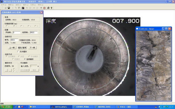
数字式全景钻孔摄像系统
Copyright since 1998 Whrsm , All Rights Reserved 鄂ICP备 11007814号 鄂公网安备 42010602001930号
DPBCS DIGITAL PANORAMIC BOREHOLE CAMERA SYSTEM was inve
nted by Dr. Chuanying Wang who visited Canada as a senior visiting schol
ar with the help of Dr. GeXiurun one academician of the Chinese Academy
of Engineering. After many years' effort, BHCTV now is a advanced visual
bole survey equipment in the international advanced level. It filled the tech
nology blank in this field and was a milestone in the development of boreh
ole camera technology. This system makes a great revolution of previous
borehole technology by imitat.
It creatively raised the surface imaging technology, suture surface image
technology and scene scans line imaging technology. This system also resol
the problem of how to get the high-accuracy panoramic borehole image,
Digital Panoramic Borehole Camera System Cutting edge of Technology
数字式全景钻孔摄像系统技术前沿
real the technology of hole's 3D visualization description and information's tal analysis, resolved the problem of how to
get integrated and accurate deep rock mass structure features. It created a new area in accurately describing rock stru
cture and has reached the highest level of international borehole camera technology.
DPBCS got four national patents and two Software copyright registrations, one patent acquir Gold Award in 13th Nat
ional Invention Exposit and this project was selected into(The national outstanding patent engineering technology ).
This system has been used in national major projects successfully and got three national provincial scientific or techn
ical award. DPBCS is a advanced intelligent exploration equipment which gather many high technology as electronic tech
nology, video technology, digiechnology and computer application technology. Its innovation is realizing panoramic image
and breakthrough traditional digital technology.
Panoramic image which transformed by specific optical transformation is
a planarimage included 3d information. By digital technology, panoramic can
be transformed into various 2d or 3d image. This technology includes accurat
ely measure and analysis geotechnical information in image. The system break
though previous simulation method and realizes panoramic technology dig
ital technology. With these technology, our system can get hole's 360°hole
wall image and borehole core's digital 3d image. Our system's outstanding
function is incomparable with traditional method.